Best chances of wintry weather appears to be west of U.S. 17 as of Wednesday afternoon. [NWS MHX graphic}
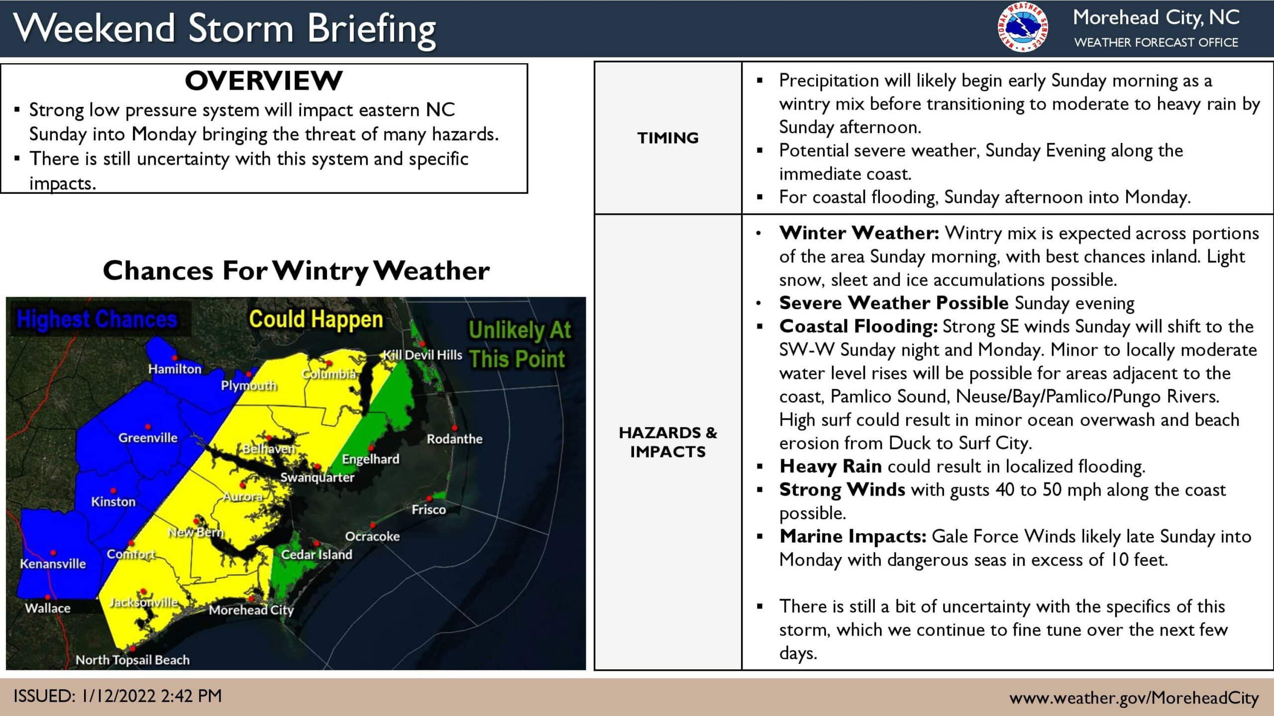
While all the attention is on the possibility of snow for areas well inland from a large storm system on Sunday and Monday, areas closer to the water and along the Outer Banks are likely to get heavy rain, strong winds, high surf and possible oceanside and soundside flooding.
“Most of the area may see a brief, light wintry mix of snow, sleet or freezing rain Sunday morning,” said Erik Heden, Warning Coordination Meteorologist at the Newport/Morehead City office of the National Weather Service.
“The highest potential for this will be the farther inland you live and with ground temperatures quite cold leading up to the storm, icy spots are certainly possible,” Heden said.
He added that any wintry mix will quickly change over to all rain by Sunday afternoon and for the majority of the event, heavy rain, wind, and coastal flooding will likely be the highest impacts.
With strong south winds quickly shifting into the southwest to west Sunday night into Monday, minor to moderate water level rises are possible across the Pamlico Sound, and adjacent rivers.
In addition, large waves will likely lead to ocean overwash and beach erosion into the day Monday.
Before the big storm arrives, a weaker low pressure system will move just offshore with a few showers Thursday night and into Friday while also stirring up the ocean.
Stay with the OBX Today Weather Center, Beach 104, Big 94.5 WCMS, 99.1 The Sound and Z 92.3 for all the latest info.
National Weather Service forecast for Nags Head, as of Wednesday 4 p.m.:
Partly cloudy, with a low around 37. Southwest wind around 8 mph.
A chance of showers, mainly after 2pm. Mostly cloudy, with a high near 52. West wind around 6 mph becoming northeast in the afternoon. Chance of precipitation is 30%. New precipitation amounts of less than a tenth of an inch possible.
Thursday Night
A chance of showers, mainly before 9pm. Mostly cloudy, with a low around 42. North wind 9 to 18 mph, with gusts as high as 23 mph. Chance of precipitation is 30%. New precipitation amounts of less than a tenth of an inch possible.
Mostly cloudy, then gradually becoming sunny, with a high near 50. Windy, with a north wind 22 to 26 mph, with gusts as high as 32 mph.
Friday Night
Mostly clear, with a low around 32. Windy, with a north wind 23 to 26 mph, with gusts as high as 32 mph.
Partly sunny, with a high near 42. Breezy.
Saturday Night
A chance of rain after 2am. Mostly cloudy, with a low around 34. Chance of precipitation is 30%.
Rain, mainly after 8am. High near 57. Breezy. Chance of precipitation is 90%.
Sunday Night
Rain before 2am, then a chance of showers after 2am. Low around 37. Windy. Chance of precipitation is 90%.
M.L.King Day
A chance of showers before 8am. Mostly sunny, with a high near 49. Windy. Chance of precipitation is 40%.